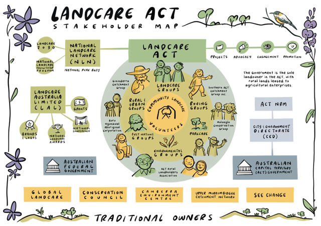
Understanding the Landcare ecosystem isn’t always easy. With its rich and complex web of community groups, government partnerships, non-profits, businesses, and other supporting organisations, it can be a challenge to explain—let alone navigate. That’s why the Landcare Facilitator Program has focused on creating something visual, practical, and powerful: stakeholder maps tailored to each state and territory, supporting national advocacy and stakeholder engagement.
The original stakeholder maps for Victoria (2020) and New South Wales (2022) were developed externally by The Forever Agenda, a facilitation and coaching company for non-profits and graphic design company Think in Colour, for the Landcare Facilitator Program. These foundational tools have since informed a broader national project now led by NLN. Originally designed for coordinators and facilitators, as part of their tailored induction packages, these maps have found a far wider audience and even greater purpose—helping everyone from policy-makers to volunteers see the bigger picture of Landcare in their region.Originally designed for coordinators and facilitators, as part of their tailored induction packages, these maps have found a far wider audience and even greater purpose—helping everyone from policy-makers to volunteers see the bigger picture of Landcare in their region.
The response has been overwhelmingly positive. Claire Hetzel, CEO for Landcare Victoria shared, “This stakeholder map has been invaluable when speaking to groups, government, funders and key stakeholders about the strength of the movement and the deep social infrastructure that has been built (in Victoria) over the past 39 years. It simplifies the complex community-government partnership that is Landcare and builds understanding of the roles and responsibilities of each stakeholder”.
We’re excited to be expanding this initiative to other states and territories. Maps for the ACT, South Australia, and Western Australia have already been completed, along with a refreshed and updated stakeholder map for Victoria. Next, we will commence work on maps for Queensland, Tasmania, and the Northern Territory, while a National Landcare map is also currently in development.
Each map goes through a careful process of consultation, iteration and refinement—culminating in a beautifully illustrated, state-specific design that includes unique species and symbols that reflect the local environment. Although there are shared elements across the movement, each state brings unique characteristics to its contribution to Landcare’s nationwide efforts.
These maps are more than just tools—they’re conversation starters. They help demystify the complex web of Landcare organisations, highlight the central role of volunteers in our movement, and make it easier for others to understand how they can connect and contribute. Jodie Lovell, NSW Landcare Enabling Program Manager commented,
“The Landcare stakeholder map provides those new to Landcare a visual way to understand how their role fits within the Landcare ecosystem. Landcare is a strong, diverse grassroots movement with our volunteers and Landcare member groups at the heart of everything we do. Landcare NSW acts as the conduit between local Landcare communities, key partners and decision makers, working to ensure that local Landcare communities are supported at every level.”
When we can communicate clearly together, we amplify our collective impact. The Landcare Landscape maps stand as powerful visual tools that bridge complexity and clarity, enabling stakeholders to see—and connect with—the intricate layers of the Landcare movement. By fostering understanding, collaboration, and alignment of efforts, these maps are driving greater impact, ensuring the movement continues to thrive and grow across Australia.

